Drones for Reality Capture

Photogrammetry Using Drones
Traditionally, reality capture involved manual measurements, time-consuming surveys, and expensive equipment. However, with the advent of drone technology, the game has changed.
Using our specialist technology, we can produce digital twins of structures and assets for multiple purposes including inspections, planning works, BIM modelling and more…

Talk to us about how we can help with your Reality Capture needs
Industries & Applications
Vertex Air's drone-based reality capture solutions cater to a wide range of industries, including:
· Construction and Engineering: Streamline construction progress monitoring, site analysis, and documentation with our accurate and up-to-date aerial surveys and 3D models.
· Surveying and Mapping: Capture precise topographic data, generate detailed terrain models, and create high-resolution orthomosaics for land surveying and mapping applications.
· Infrastructure Inspection: Conduct efficient inspections of bridges, power lines, pipelines, and other infrastructure assets to identify potential issues, monitor conditions, and improve maintenance strategies.
Virtual Inspections of Assets
Easy Navigation
Accuracy and Precision
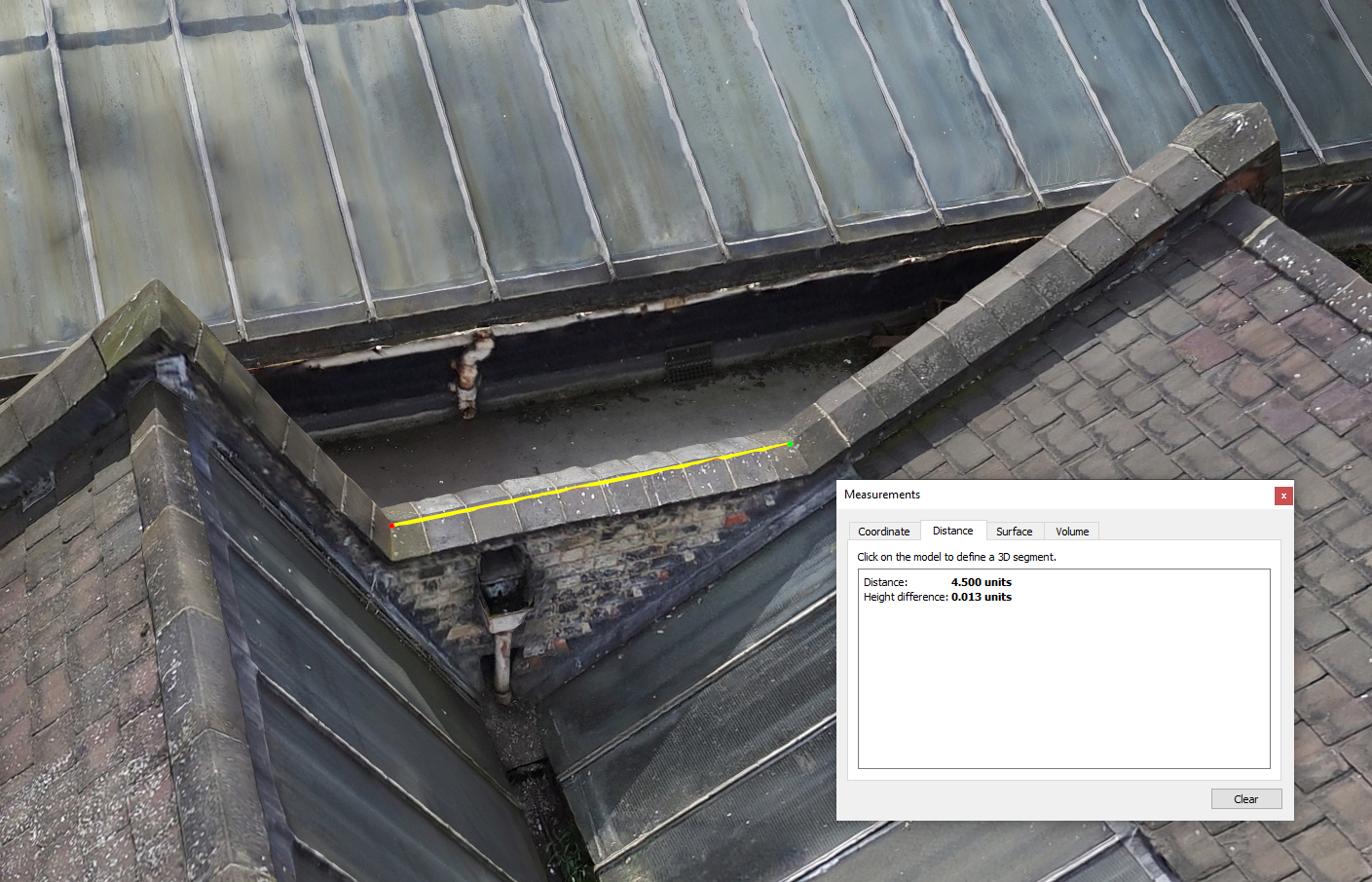
Equipped with advanced sensors and GPS technology, our drones capture highly accurate data with precision down to centimetres. This level of detail ensures reliable and precise measurements for your projects. Using our advanced drones equipped with high-resolution cameras, LiDAR sensors, or other specialized equipment, we collect data according to the project plan.
Versatility
Our drones are capable of capturing a wide range of data, including aerial imagery, topographic maps, 3D models, and point clouds.

Planning and Consultation

We collaborate closely with our clients to understand their project objectives, specific data requirements, and any unique challenges. This allows us to develop a tailored plan that optimizes data collection and analysis.
Data Acquisition: Using our advanced drones equipped with high-resolution cameras, LiDAR sensors, or other specialized equipment, we collect data according to the project plan. Our skilled pilots navigate the drones with precision, capturing the required data from the desired vantage points.

Data Processing
Once the data is acquired, our team uses software to process and analyse the raw data. We employ techniques such as photogrammetry and LiDAR processing to generate accurate 3D models, maps, and other desired outputs. We deliver the processed data in the desired format, whether it be point clouds, orthomosaics, DSM or GIS-ready datasets. Our team can also assist with integrating the captured data into your existing workflows and systems.

Internal photogrammetry
Using our confined space drones, we can produce digital twins of internal assets such as bridges, culverts, sewers etc…
Using a digital twin, inspections can be performed remotely via a computer instead of on site giving benefits such as cost reduction, efficiency of works, safety and more.
Our drones also offer the capabilities of capturing LiDAR Data to produce a survey grade Pointcloud simultaneously.

To browse the full range of our services, click here or to discuss your drone building roof survey or inspection requirements, LiveChat below, email us on info@vertexaccess.co.uk or call 01709 379 453