
PHOTOGRAMMETRY /
DIGITAL TWINS
Virtually Inspect Assets
Photogrammetry is a 3D model created from still images to create a textured mesh. The use of drones has allowed for creation of these meshes in previously awkward and inaccessible spaces
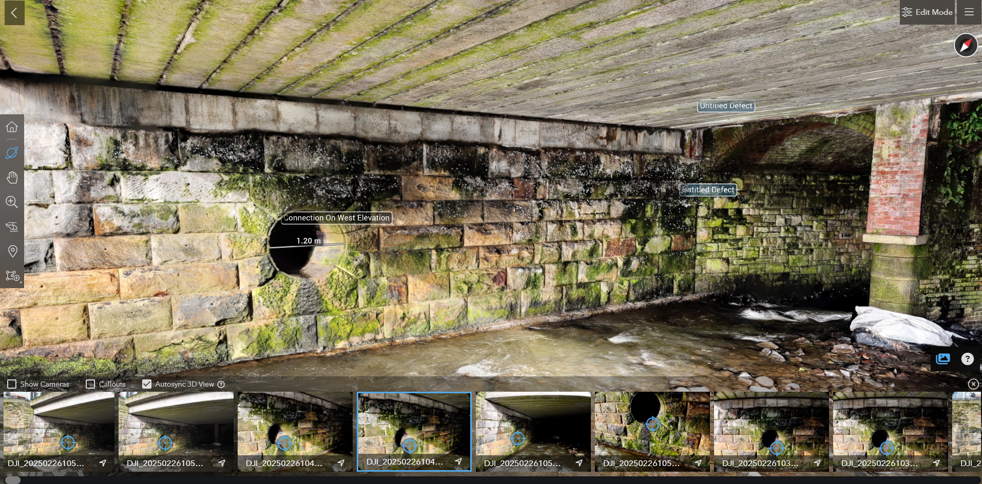
Leveraging a fusion of High-Resolution 3D models and detailed inspection imagery, Vertex Air has been providing advanced digital inspection capabilities. By seamlessly integrating these data sources, we enable precise, remote asset analysis for our clients.
Defects and annotations are accurately positioned within the 3D environment, providing a comprehensive and spatially referenced understanding of asset condition. Accurate Measurements can also be plotted on to our models. This approach facilitates enhanced collaboration, improved defect tracking, and streamlined maintenance planning, ultimately leading to more efficient asset management.
3D Model
3D Model With Inspection Shots Synced To Position

High Res Image Overlay
Accuracy & Precision
Equipped with advanced sensors and GPS technology, our drones capture highly accurate data with precision down to centimetres, ensuring reliable measurements for your projects. To enhance this accuracy further, we utilize cutting-edge RTK (Real-Time Kinematic) enabled drones. This technology allows us to achieve global accuracy of around 20mm in real-time by receiving corrections from ground-based stations.
In addition to RTK, we employ GNSS (Global Navigation Satellite System) base stations. These fixed, highly accurate reference points on the ground provide an independent coordinate system for our surveys, ensuring our models are consistently accurate across your project site. By referencing our drone data against these base stations, we minimize potential errors and maintain high-quality spatial accuracy.
Furthermore, we strategically use Ground Control Points (GCPs). These are precisely surveyed points visible in the drone imagery, which we incorporate during data processing. GCPs act as vital anchors, ensuring our 3D models and other outputs are accurately georeferenced.

3D Model of Complex Dust Extractor Hosted Online
Get in touch with us to discuss your project needs.
Industries & Applications
Vertex Air's drone-based reality capture delivers accurate and efficient solutions for a wide array of industries:
Construction and Engineering: Streamline progress monitoring, site analysis, and documentation with our accurate aerial surveys and 3D models for enhanced planning and coordination.
Surveying and Mapping: Capture precise topographic data and generate detailed terrain models and high-resolution orthomosaics for comprehensive land surveying and mapping applications.
Infrastructure Inspection: Conduct efficient inspections of bridges, power lines, pipelines, and other assets to identify issues, monitor conditions, and improve maintenance strategies.
Environmental Monitoring and Conservation: Gain insights into environmental changes with high-resolution data for habitat mapping, deforestation monitoring, and coastal erosion analysis.
Cultural Heritage and Archaeology: Document heritage sites with precise 3D models for research, conservation, and virtual access.

3D Documentation of Heritage Building
We collaborate closely with our clients to understand their project objectives, specific data requirements, and any unique challenges. This allows us to develop a tailored plan that optimizes data collection and analysis.
Once the data is acquired, our team uses our software to process and analyse the raw data. We deliver the processed data in the desired format, whether it be point clouds, orthomosaics, DSM or GIS-ready datasets. Our team can also assist with integrating the captured data into your existing workflows and systems.
To discuss your 3D modelling needs and requirements please call 01709 379 453 or email info@vertexaccess.co.uk

Large Scale City Centre Digitalisation
Not What You Are Looking For?
Click below to see all of our drone services or get in contact with us to discuss your project needs
